Sunday, March 29, 2009

Over Before It Started


People are getting excited about gliders again. I have been emailing and meeting with three prospective students. "When can we start flying?" they ask, filling me with empathetic eagerness. The club glider had some work done over the winter, and is almost ready for its annual. The towplanes (we may have two this year) are ready. Wahoo!

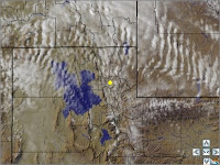
Yesterday we had the kind of transitional spring weather that can get you down if you don't know how to deal with it but get you excited if you recognize it for what it is. The Salt Lake area was sunny and warm, with light south winds, but flying into Idaho got us into an area of overcast and continuous light turbulence with strong up- and downdrafts. The power pilots were bummed out, but the glider email network was abuzz with "I think I saw a lennie" (that is, a lenticular cloud) and "I flew through a 15 knotter" (that is, a 1500fpm updraft). Someone posted a satellite photo showing mountain wave activity. But nobody actually rigged up and flew. Soon!

In fact, I had shown the same satellite photo to one of my power students, who is a wonderful student with the tiny fault that he is not interested in soaring.


But it snowed all day today, and the peak gust in Pocatello was 48 knots. It snowed in Logan and along hte Wasatch Front. Needless to say there was no fun flying.

But soon!

Labels: , ,

Sunday, March 22, 2009

Busman's Holiday


Spring Break has arrived, and let me tell you the faculty are as glad as the students!

Of course I flew yesterday, but not just boring holes in the sky. I got into our club Archer wearing a sport coat and nice slacks (but no tie), and flew down to Provo, UT, where I spoke at a mathematics conference (the Intermountain Section of the Mathematical Association of America, to be precise).

I was speaking at 11:30 and figured on 1.5 for the flight (as opposed to 3.5 for the drive), but I wanted to hear some of the other speakers, too, so I was in the air early enough to see the sun rising over Malad, Idaho. Salt Lake's Class B was quiet, and I heard "Cleared into the Class B airspace" while still 50 DME from the I-BNT localizer (the center of the Class B).

Provo was busy with 2-seaters of various flavors doing touch-and-goes and a Citation that did a honking turn to "squeeze" into the pattern ahead of me. But the ground controller gave me a friendly "Taxi to the ramp via A, and welcome to Provo," and I got to park close to the FBO.

Provo always leaves a bad taste in my mouth from a King Air trip a few winters ago. The weather was bad, and I mean bad: ILS minimums and surface temperature 0 Celsius. The passengers were late, and it snowed on the airplane while we were waiting. I had a new guy riding along for the experience, so we talked about the ground icing portion of the Operations Specifications (each carrier has individual rules issue by the FAA, called the Operations Specifications, or Op Specs).


The passengers showed up and we loaded them on. The deice truck came and sprayed us with hot alcohol. I started up, which is a complicated procedure in the King Air. A certain number of MASTER WARNINGs and MASTER CAUTIONs are normal, because the generators and inverters go online then offline then online, but this time there was an extra MASTER CAUTION for an EXT PWR light. That meant that we were plugged into the external power cart, through an access panel below the right wing outboard from the nacelle.

But of course there was nothing there. I tried recycling the battery bus, but the light stayed on. The only thing that I could think of was that the spray of the deicing fluid was shorting something in the access bay, so I shut down. It was cold and humid, the fog sticking to everything. Everything was orange in the glow of mercury vapor lights piercing the fog.

We got out and cleaned the deicing fluid out of the external power plug, blew on it a little to make sure it was dry. I felt the wing (dry) as I got in, and we started again. No light! We taxied to runway 18.

Snow was falling now, and as we took the runway I looked out onto the left wing. It was covered with snow, almost an inch worth. There is no way that we could take off like that, and I made the hard call: we're going back to get deiced again.

It made for a long night (I think we went to Fargo that night), and the company lost a bunch of money. In the morning I did the carpet dance for the Director of Operations (yes, I had to get deiced twice). I pretended to be contrite but I knew that I had done the right thing.

(This is the same DO who got angry one summer when too many pilots were out of duty time. It seemed to me that when all of your pilots are out of duty them then the only proper response is "Thank you!")


But it was a beautiful day in Provo. The Wasatch Front is right there when you're on the BYU campus (that's where the conference was held), and students were out running and sunning and enjoying spring. Of course there is no alcohol on the BYU campus, but better yet for me was that I needed no deicing alcohol to get home. (This time I would have had to pay for it.)

The weather was gusty so there were more than a few bumps on the way home. The strong thermals and strong ridge lift got me thinking about flying gliders again, soon, but I flew the airplane I was in and held altitude. I landed at home with a 12 knot crosswind component, and went straight to the monthly EAA meeting.

I thought they would make fun of me for wearing a sport coat, but the only comment I heard was "Nice crosswind landing." They'd all stood on the ramp and watched...

Labels: , ,

Friday, March 13, 2009

It's in the Cards


I sat down with my instrument student and started point out the features on the enroute chart of our local area. He had just done a good job with the infamous Pattern B, and it was time to start to learn to navigate.

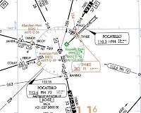
"Now, here at Pocatello they also show the localizer."

"Why's that?"

"Because it helps define TYHEE. If the localizer is part of the enroute structure they show it." I showed him the legend, which obscurely notes "ILS Localizer course with additional navigation function."

"I thought the localizer course was 211." Look closely: the chart says 208. The change was made about five years ago; the ILS chart has the correct bearing.

I have always been impressed with the way the chart makers work. There are so many details, and so many tiny decisions that can make a big difference in readability. Chart errors, in my experience, are rare. But here was a chart error.

The front of the NACO charts has a big box. "FOR CHARTING ERRORS CONTACT," giving snail mail and email addresses, plus a phone number. As much as I would have like to talk this over with somebody, and to hear their reaction, time has been very short this week and I sent an email.


"Maybe they'll give you a year's free subscription," my student suggested.

Alas, they did not. I got the following email.


So they had already fixed it. No, I don't know what Everest is (other than a mountain in the Himalayas).


My new enroute charts arrived on Wednesday (before the AIRAC date, this time) and I immediately tore open the package and dug out the L-11 chart. The localizer course was correct.


What I don't know is whether the incorrect localizer bearing was shown on only one edition of the chart or on many. I was impressed that they caught the error, though. Think of all of the frequencies, bearings, latitudes, longitudes, elevations, variations. airway names, runway lengths, and other data on these charts. While I am pretty sure that the chart publishers depend on local pilots to catch errors, in this case they caught it before the "local" guy did. Good job!

I still would like a year's free subscription, though...

Labels: , ,

Friday, March 6, 2009

Line of Sight


Winds aloft were 260 at about 35, and the plan for my instrument student was to fly a little triangle (JATTS - ROCCA- PIH - JATTS) based on two local VORs. The strong wind mean noticeable wind correction angles on the north-south legs, and ridiculous groundspeeds on the east-west legs. The first lap would be with me flying the heading he commanded, and, of course, no hood. The next lap he would do it all, under the hood.

But we were in his airplane, not a rental, and the wind was gusting to 32 knots. Was he up for it? Absolutely!

We fooled around with E6Bs to estimate the wind correction angles and crosswinds on each leg. These worked out to be 12 degrees on the north-south legs (his first guess had been 30). He picked a heading to intercept the northbound airway, and we launched.

The ATIS said that the cloud bases were at 3600'AGL, but in fact the ceiling was around 2000'. We weren't equipped for ice, and there were no pilot reports about icing or tops, so we cruised along at 1500' AGL (500' below the bases), getting bumped a little but having fun.

The #1 VOR was set to PIH, with the OBS on 318. The #2 VOR was set to IDA, with the OBS set to 233. At first we focused on #1, but he began to wonder when the needle on #2 would start to move. "Be patient," I counseled, but I know that's hard. I made him ignore the handheld GPS on the windshield post and estimate how far along the airway we were.

But the impatience was too much. "We've still got a NAV flag on #2," he said, which is a pretty sharp observation. There was no audio identifier, either.

"How far are we from the VOR?" I asked him.

"Can I use the GPS?" he asked.

"Sure, I replied, but it's about 42 miles."

He punched some buttons. "Forty-two! How did you know that?"

So I showed him on the chart how JATTS was 40 miles from IDA, so the distance was a little more than 40 miles. The extra 2 was a lucky guess.

"So why aren't we getting IDA?"

The answer, of course, is that we were too low. VHF and UHF signals are line-of-sight, and we were below the horizon.


This incident reminded me that practice is an essential part of learning. We hear and read that VOR signals are line-of-sight, but the visceral knowledge (what Heinlein called "grokking") does not begin until we experience it in the field. Doctors don't just go to medical school: They spend more time in internships and residencies, practicing with whatever patients walk in the door. Cooks don't just read recipes; they cook, based on what is ordered, and learn to adjust for the variations inherent in ingredients, weather, tools, and the like. I've heard the great chef Escoffier quoted as saying "A cook does not know how to prepare a dish until he has prepared it 1,000 times."


But some people seem to think that you can train a pilot in a simulator. A simulator is a wonderful tool; see this post about how I'm using the X-Plane app for the iPhone to improve my own glass cockpit scan. But it has limitations. No simulator session involves flying at a low but safe altitude over the desert and trying to navigate by a VOR that is too far away, or whose signal is blocked by higher terrain in between. Simulator training alone does not make a pilot (see Windsor's comment on this post).

Pilots need to practice, just like doctors.

Labels: , ,