Tuesday, December 20, 2011

Lost

According to this article on AirTrafficManagement.net, as well as others, the Federal Aviation Administration is getting serious about decommisioning as many VHF Omni-Range (VOR) stations as possible, leaving behind a skeleton system in case of GPS failure. This is a testament to the success of the GPS and WAAS programs, which have demonstrated their utility and reliability over, what, millions of flight hours?

I'm an old-fashioned guy: yes, I own a sextant, but the last time I tried to take a sight I had to knock on my neighbor's door and ask when he had moved to Montana (and that was so long ago that he has since moved to Utah). But I don't use the sextant in flight, and in fact with the rise of tablet apps (I've been using both Skycharts and FltPlan.com), I don't use paper anymore, either. I have a current sectional chart for my local flying area, and current Low/Enroute IFR charts, but when those expire I will probably switch to WAC charts for "emergency" back up. I use a yoke-mounted VFR GPS for navigation, which merely supplements the VOR/DME for IFR flight, of course (our club can't afford a panel mount GPS right now).

One other thing: I miss keeping a paper navigation log, but have found a nice hack: make a pdf of the navigation log from whatever source you like, and open it in uPad, another app. This allows me to write on the nav log, noting clearance, OOOI times (Out-Off-On-In), time-of-station-passage, times when I switched tanks, and the like.

Do you have trouble remembering the ATIS code? I form the letter in American Sign Language; that little bit of multi-modal memory manipulation seems to do the trick. Some pilots "write" the ATIS code on the yoke with a finger. Same idea. As for the ATIS content, I set the altimeter, so there's no need to write that down, and then pull up the approach to the runway in use, so there is no need to write that down, either.

But back to the VORs. I still use them!, even when flying VFR. I know I'm not supposed to, but I hearken back to this advice from Bowditch's American Practical Navigator, available online from Wikisource:


[Navigation] includes the routine use of several different navigational techniques, both as operational checks and to maintain skills which might be needed in an emergency. Any single navigational system constitutes a single point of failure, which must be backed up with another source to ensure the safety of the vessel.

So I still tune VORs.

Many years ago, when airliners had VOR and DME (no groundspeed) and ADF, I was a passenger on a United flight to San Diego, dutifully listening to Channel 9 (United puts ATC on its entertainment system). The whole way from Chicago the Morse letter 'W' could be heard in the background. What was 'W'? Checking the charts when I got home, I saw that 'W' was a powerful marine beacon located at Point Loma, near Lindbergh Field. Somebody up front wanted to have a needle pointing to San Diego for the whole trip...

Alas, marine beacons have disappeared from aeronautical charts. The most interesting area was Long Island Sound, where all of the beacons were on the same frequency but transmitted on a schedule. Thus, you could triangulate with a single receiver: one line of position from beacon #1, the next minute a LOP from beacon #2, the next from #3, and there you were!

Here you see an old (1989) Sectional Chart Legend, showing the beacon in question and how to use it. The "H+00 & ev6m" for Point Loma beacon (identifier W) indicated that it broadcast for the first minute of the hour, then every 6 minutes. So, if your watch was accurate, and the time was H+06, you knew that you were listening to Point Loma. There were other beacons along the coast, with broadcast schedules "H+01", "H+02", etc.

Some people used these.

Some people still tune VORs.

Some people still tune ADFs.

Some people take comfort in seeing the the appropriate constellation ahead.

Not just me.

BUT, the question is whether this is worth the expense of maintaining all of
those stations. (I'm not suggesting that we decomission the North Star!)

Probably not.

Labels: , , ,

Saturday, April 9, 2011

Personal Minimums

People have thrown the phrase "personal minimums" around for a long time, but I think there's been something missing from the discussion. And while I am writing this for Sport Pilots, it really applies to every pilot.

The safety gurus try to make the "personal minimum" decision sound easy, but I've never found it that clear cut. A few years ago I was flying some very nicely equipped King Airs, took annual simulator training, and had to take a semi-annual instrument check. If it was legal I could handle it. Well, at least "legal" in the King Air. One winter afternoon I took off in my Taylorcraft and headed west across the desert. It was VFR but the white sky and snowy ground meant that there was no visible horizon. The T-Cart had a venturi driven turn needle that seemed to work best on hot days, so my instrument proficiency was of absolutely no use. I turned around and landed.

In other words, a pilot who was IFR proficient below 1/2 mile visibility cancelled a flight because it wasn't good enough VFR. It takes two to tango.

The FARs contain a huge loophole for charter pilots (14CFR135) that I flew through regularly. To launch on a charter flight you could use any combination of reports and forecasts to make sure that the weather would be legal when you arrived. So a forecast for bad weather that was worse than the reported weather meant I could go. Incredibly poor reported weather could be ignored if the forecast said it might improve, even if every ounce of common sense indicated that the forecast was wrong.

FAR 61.315 spells out sport pilot privileges and limitations. These seem pretty clear-cut: no night flight, no flight above 10,000 feet MSL except within 2,000 feet of the surface, no flight with less than 3 miles flight or surface visibility. The last one means no Special VFR, and no taking "advantage" of the reduced visibility required by FAR91.155 for Day VFR in Class G airspace. (This so-called advantage is the classic example of something that is legal but not safe.)

Furthermore, a Sport Pilot must maintain ground contact. A Private Pilot may legally fly above an overcast, and sometimes this can be safe. Sometimes. But a Sport Pilot may never do this.

The reason Sport Pilots have these limitations is that they are not required to have instrument training, while Private Pilots must have three hours of "hood" time. It always seems a shame to put someone under the hood on a pretty day, but still I make my Private Pilot students fly to the practice area and back under the hood, and they also spend some cross-country time unable to watch our lovely scenery go by.

Even if you are a private pilot, you are limited to these conditions if you have limited yourself to Sport Pilot privileges by using your driver's license as your medical.

So what's the problem?

The problem is that there's no mention of the forecasts.

I've visited a few EAA chapters recently and I have heard a lot of talk about Oshkosh. Some of it has come from me, because the last time I made it to Oshkosh was before my teenagers were born, and it's long past time to go again. As I think fondly of the great people I met there and the wonderful things I saw and learned, I can't help but recall that every time I have gone to Oshkosh it's been IFR. I think one time the visibility was 2 miles, but never 3 while I was flying. If you get a standard briefing then you'll get a NOTAM for IFR conditions. Pay attention.

Enroute it may not have been IFR but VFR flight was a lot more comfortable above the convective layer. If there are scattered cumulus then it's OK for a Sport Pilot to be "on top", but when the clouds are broken being on top is questionable and when the clouds are overcast it's illegal. The Area Forecast should give you some information about the cloud tops.

Any trip east from my home airport involves lots of mountain flying. There is a route from home to Oshkosh that stays below 10,000 feet MSL, but there are lots of wind conditions that make 2,000 feet above the ground too low for my taste: think about the Steve Fossett accident. And more than once I've found the valley I intended to fly through blocked by rain or snow. "Sometimes you just have to fly toward the blue sky," but what if that means climbing above 10,000 MSL? Can your airplane do it? Can you do it, legally?

So you really have to pay attention when you see those little hints like VCSH in the TAF. (That means showers in the vicinity.)

The missing piece of the personal minimum decision comes from understanding the forecasts. TV weather is fine for a local flight, but when you set off on that looooong cross-country you really need to understand the forecasts.

Your ability to obtain, read, and interpret a forecast becomes part of your "personal minimums." If you can't understand the forecast then you shouldn't go.

Any pilot who intends to fly any serious cross-country really needs to practice with TAFs and Area Forecasts

Labels: , , ,

Tuesday, February 8, 2011

Tough Day at Jackson Hole

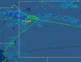
It looks like yesterday was a tough day in Jackson Hole, Wyoming (KJAC). I looked Flight Aware to see how a friend was doing; apparently he forgot about the strong west wind and flew through the localizer after the procedure turn:


He was better off than American 2253, a Boeing 757. It looks like they held at Dunoir VOR for quite a while before diverting to Salt Lake City. I've done about that many turns in that hold waiting for ILS minimums.


After cooling their heels in Salt Lake for a while, American 2253 tried again. This time, it looks like they went to Dunoir for the ILS-19 before changing their minds and opting for the VOR-DME 1 approach. (You can tell which approach because it looks like they flew the 16DME arc.)

If the weather was decent (which might have been the case even though the airport was showing 3 miles visibility in snow) the passengers got a nice tour of the Gros Ventre and Wind River ranges.


When I flew King Airs I went to KJAC a lot. I often touched down as the tower opened (0700LT). This meant that I had been in the air at 0620 or so, so I had been at my home airport at 0515, which means I left home at 0445, which meant that I had to get up at 0400.

I don't miss the 0400 wakeups...

Labels: , ,

Friday, October 8, 2010

Karma

The weather looked a little iffy so I had filed IFR the night before. In the morning the weather was good, but I decided to fly the trip IFR anyway.

At the hold short line I called "ready." The tower told me to hold for release due to an inbound SkyWest Brasilia. Before i could say "I'll depart VFR," though, the Brasilia cancelled IFR.

Now I was in karmic debt.

Fifteen miles from the destination Center cleared me to climb so he could release a SkyWest RJ. "How about `cancel IFR'?" I came back. "Those are the magic words!" he replied, and I continued my descent.

SkyWest cancelled for me. I cancelled for SkyWest. Now I was in karmic balance.

Labels: ,

Friday, July 23, 2010

Tanking Up

Yesterday's training flight brought me a lot closer to total instrument proficiency, although I still have a way to go. My goal is perfection, a goal impossible to reach; the value is in the trying. With the medical problems both my currency and proficiency lapsed, despite some work with various Flight Training Devices (aka simulators).

I did not make things easy for myself. First, all of our club planes are tied up, so I rented a 172XP. I've flown this XP a lot, but never IFR. Unfamiliarity with avionics is a link in a lot of accident chains. In this case I said "Where is the ADF needle?" out loud, but that's the same kind of confusion you see when someone doesn't understand what, say, a Garmin 430 is showing, or how to get it to do what you want. Time spent looking for a needle in a haystack is time not spent managing the airplane. And, with no autopilot, not managing the airplane meant that my heading control was by no means perfect.

Of course it was hard to tell what my heading was: This XP's heading indicator precesses too quickly.

The airplane has no DME and I was using a handheld GPS as training substitute. Between the NOS approach book and the GPS my lap was pretty full. The polite phrase for this disorganized behavior is what the Practical Test Standards now call Single Pilot Resource Management. I'm planning to buy a new GPS, so this area will need some more work. I can use my struggle with it to help my students, especially the ones with their own planes, which tend to have every portable toy available. (The worst I ever saw was the owner of TBM-700 who, despite having every Moving Map, Primary Function Display, and Multi Function Display known to humanity installed in his panel, got lost while being vectored for an ILS.)

The wind was an issue, too, in a good way: a strong westerly flow that distorted my mostly north-south approaches, and made timing in the hold tricky (outbound groundspeed 80, inbound groundspeed 140). That's just good practice.

I flew one approach to an airport just north, planning to intercept the transition for the ILS back home. The first approach went fine, despite the spinning heading indicator and large wind correction angles, because I used the GPS "track" display to make sure that we were moving in the right direction. I started the published missed approach, and tried to tune the VOR for the transition. The NAV flag stayed visible and there was no ID, although I didn't remember seeing a NOTAM in my DUATS briefing.

It was time for plan B. I tuned the ADF to the outer marker for the ILS and headed there. This was a fine plan, except for something else that was not in my briefing. Fire season has begun, although due to El Niño and a late monsoon it is starting late. There were two heavy tankers (P-3s) and two SEATs (Single Engine Air Tankers) working the fire, and they were coming back just a little east of the localizer. I had a good safety pilot and we spotted everyone, but I have done a lot of fire fighting and know that the tanker crews are busy; holding at the marker would definitely be in their way. (I checked: there was no Temporary Flight Restriction last night, although there is one this morning.)

So now it was time for Plan C: hold at the VOR, then head out for the ILS.


You just don't get this kind of rapid decision making in any of the simulator scripts I have followed. The simulator has a lot of value, but in any case you have to fly to get the full picture


After we were done, Dan (who is not instrument rated) asked me how often I fly approaches in IMC. The answer was embarrassing: the last one was about two years ago. My medical difficulties explained a lot of this, but still...two years? I had filed IFR in that time, and flown plenty in IMC, but always got a visual approach. When I flew King Airs or freight I flew a lot of approaches, but I haven't been PIC of a King Air in a few years. My personal flying is in airplanes that cannot handle ice, so the winter is dicey at best. We tend to vacation to the east; if we took a trip to the Oregon coast there would be plenty of approaches.

Be that as it may, I am current and ready. The trick will be to keep the tank full and stay that way. I wonder if my wife would like a trip to Oregon for her birthday?

Labels: , ,

Friday, July 9, 2010

Missed Approach Fix


With the explosion of RNAV approaches, which end at a "Missed Approach WayPoint", the phrase "Missed Approach Fix" has become deprecated. But yesterday's training flight brings to mind two new meanings.

Many of us think of flying as an addiction, and with my new medical certificate I have finally been able to get a "fix." Yesterday, another pilot-professor at my university and I rented a Cessna 172 and headed out for the proverbial $100 hamburgers. Actually, I chose the heart-healthier $100 turkey sandwich. Anyway, one of my great passions is instrument flight, and I needed a couple of approaches to stay current. Boy, I've sure missed my approach fix!

Training without a debrief is almost useless, so this morning I went over the approach plates to see how I'd done.

The hold at the marker and the ILS went pretty well: I blame the one-dot deviation at 400' AGL on wind shear [insert sheepish grin here]. Then I headed out for a VOR approach. I've posted the libretto to the left so you can follow along. I was a little rushed (after all, it was lunchtime and I was hungry), but intercepted the radial and flew the procedure turn as charted.

I consistently asked Dan to clear my turns. This is one of my markers for instrument proficiency and situational awareness: when a student warns me about an upcoming turn I know that she or he has enough mental capacity left over for some situational awareness. If the student is saturated, there will be no warning.

I called the tower procedure turn inbound, got established and descended to 4920' MSL way too early, so Dan got a nice view of the tree tops as we flew along. I figured that 3DME would make a good visual decent point (VDP), and things were a little busy so when I got there I took off the hood and landed.

Looking back, I completely ignored the AZAJI fix minimums! I had DME (actual DME, not a GPS!), so I could have descended to 4640' MSL! So while my approach was "legal", it wasn't efficient because I had missed a fix on the approach!

Two missed approach fixes on one flight, one positive, one negative. So the day was neutral, right? No: when I got out my log book I realized that I needed three approaches for currency.

That means I get to go flying again!


By the way, I have really learned a lot from the FltPlan.com newsletter. It highlights changes and trends in procedures for aircraft with more advanced avionics.

Labels:

Wednesday, July 7, 2010

I Hate It When That Happens

Someone on my twitter feed recommended a video on flying missed approaches, and I was all set to cut-and-paste it into the blog right here. But I watched it first and decided to reject it. The video, not the landing, that is.

Missed approach - when you get to the bottom of an instrument approach and don't see what you need to see (which, in the USA, is set out in 14CFR91.175, or, more colloquially, "THE RUNWAY") - is a tricky maneuver. From my first day as an instrument instructor I emphasized what was at stake: you are low and lost. But this does not mean that you panic: every approach ends in a missed approach, and "briefing" [airline pilot talk for "preparing"] the missed approach is part of briefing the approach. In fact, during my one-and-only-airline interview, some of the pilots in the sim check had to fly the missed approach, because they had not briefed it. A clear case of appropriate consequences for misbehaving.

With this in mind, the missed approach is not a panic maneuver. But this video recommends "cramming" the throttle forward, and the pilot's hand reaches for the flap handle much too quickly. Plus, my sensibilities are offended when someone in training utters the phrase "going missed." This is no time to sound cool; this is time to be cool, meaning disciplined, and using the proper phraseology.

What's wrong with cramming? A lot of my IFR time is in Senecas and King Airs; in either one of those, "cramming" the throttles (or power levers, as appropriate) will hurt something. Advance the power slowly and smoothly.

And the clean up? Barring engine failure, there is no hurry to reconfigure. In fact, you often have to wait. In the Seneca we typically flew the ILS indicating 120 knots, but the maximum gear retraction speed is 107. If you try to raise the gear right away, you will hurt something.

As for flaps, raising flaps induces a pitch change and, in some airplanes, causes some sink. Neither one of these is much fun when you are in the clouds down low.

So, climb to a safe altitude, then clean up.

I'm flying some practice approaches tomorrow, for the first time in a while. That is an appropriate time to cram!


[Addendum] After the original post, I checked some other videos of missed approaches on YouTube. One in a B737 simulator has the Pilot Flying calling "Flaps Up! Gear Up!" while the voice from the radio altimeter is saying "100 feet [AGL]." Now I'm not qualified in the 73, so maybe this is correct, but I doubt it. Correct me if I am wrong.

I was once a passenger on an MD-80 that had a bird strike seconds before touchdown at Oakland. The crew went around, and flew the whole visual pattern with gear down and landing flaps. Why? They were afraid of structural damage, so wisely decided to leave the airplane in a known flyable configuration.

Labels: ,

Tuesday, February 9, 2010

Against the Current

When you don't fly professionally (or, worse, when you don't have a medical certificate) it's important to take advantage of every opportunity. Looking at this morning's forecast of nothing better than 600 overcast, I figured that today would provide none. So I cheerfully went to class, then across campus to lunch, talking with a visitor from Spain. I couldn't help but notice that the university weather was a lot better than 600 overcast, but sometimes the city is in the clear while the airport is in the soup, so I once again dismissed the thought that kept interfering with what should have been my mathematical frame of mind. I settled into my office chair. I couldn't help myself: I logged onto DUATS and got a weather briefing. "Just for practice," I told myself, "just for practice."

Maybe practice makes perfect: the metar was KPIH 092353Z 03007KT 10SM SCT048 00/M06 A2998. How much research did I need to get done this afternoon, anyway? Hadn't I put two new theorems in my notebook just yesterday?

But it's not so simple when you don't have a medical certificate. I started phoning pilots. Greg was already at the airport and ready to fly. It's time to fly!

Greg and I have flown a lot together (I instructed him for his CFI), so settled into our personal patterns easily. One thing about flying with Greg keeps me at the top of my game. Greg used to be a controller. When there's traffic, he sees it before anyone. Better yet, he knows how to point it out, so when he says "There he is, 3 o'clock, down low," you look and find it right away, too.

And there was lots of traffic on this pretty afternoon. We went to Blackfoot for a touch-and-go, departing just as a flight of three high-wing taildraggers arrived, about 200 feet in trail from each other. Someone kept calling them "party of three" on the radio, as if it were a restaurant.

Heading home, the Worst Controller I Know was working the tower. "Uh-oh," we said, almost simultaneously, "this should be interesting." I wanted to fly a practice ILS, but there was another airplane already on the approach. Well, it was not exactly on the approach, it was outbound to the marker. So maybe Mike (it's a small town, we know who's flying what) was 6 miles from the marker, outbound, while we were 6 miles from the marker, inbound. By the time Mike got there and started outbound for the procedure turn we would be in the hangar. Somebody was swimming against the current, and it wasn't Mike, and it wasn't me.

But the controller didn't see it that way. So I did a 360 (under the hood), and when I rolled out there went the outbound 182, 1000' above us, headed away from the airport.

Somehow I got the controller to see that we were in front of the 182, where we had been all along, so we did the approach. The controller kept micromanaging, though, and his frequent irrelevant radio calls threw me a dot off. Grrrr. Greg was laughing loudly, but was also careful not to key the mic while he did so.


Done with the ILS, we were in closed traffic. A Falcon called, on the GPS approach. "This ought to be fun," Greg said, and I agreed. Four VFR airplanes was over this controller's personal minimums. I thought about calling the tower chief on his cell phone...

The frequency was busy and The Controller kept changing his mind about the landing sequence. I didn't help. He put us ahead of Mike in the 182, but I knew Mike needed to do a circling approach, so I volunteered to extend my downwind to let Mike finish. But meantime the Falcon was arriving, probably indicating 170 or so.

"There he is," Greg said, and sure enough I followed his eye to the Falcon. The eyesight pressure was on.

"Looks like a 900," I said.

"Yeah, beautiful airplane," he said, not missing a beat. Of course he was right.


So I didn't just get to fly. I got to be bury, mixing it up with The Controller and watching my spacing from other traffic and even avoiding a bird strike. the kind of flying that keeps you sharp. I hope. At the end of all this, I was surprised to note that I am instrument current until the end of March. Without a medical certificate it won't do much good, of course, but it will be nice to be ready.

Labels: , ,

Saturday, June 13, 2009

Filing IFR

You probably follow one or more online forums. They can be a good source of information, and they can be a good source of mis-information. I skip any post that starts with "I'm not instrument-rated but..." or "I'm not an instructor but..." or "I'm not a doctor but...". At least they are honest.

Today's discussion began in a website newsletter and in an online forum, so use some judgment. The Aeronautical Information Manual may or may not change based on it. But the final advice is so compelling that I am sure it worthwhile. It's about one of my pet peeves,

Filing Direct


Look back this post about lost communications. One of the many big puzzles is what to do when the clearance limit is the destination airport, for example, "You are cleared to the Boise airport via as filed, climb and maintain 12 thousand, departure with Salt Lake Center... ."

Boise airport is not an initial approach fix (IAF), so what do you do? The rule (14CFR91.185) is almost clear: you should go to the Boise airport, then fly to and hold at an initial approach fix (IAF) until the appointed time. Strictly speaking, you are supposed to go to the clearance limit, and then go to the IAF. In principle, you can go to the clearance limit by following the approach path at the lowest of the 91.185 altitudes (that is, not descending at all). But then what? How do you get the to the IAF without compromising your safety (don't hit anything) or someone else's airspace?

The punch line: some people now recommend that you include an IAF in your flight plan route. This makes a lot of sense to me.

The alternative is to just file "direct" to the destination; one wag justified this particular bit of laziness by saying that "filing direct tells ATC that they can put you wherever they like." This is fallacious in two ways. First, ATC puts you wherever they like no matter what, so they gain nothing. Second, if your destination airport is in a different center's airspace, the computer may not know where it is, so a controller will have to go look it up and enter your flight plan by hand. Filing direct doesn't save ATC from work; it gives them more!


Let's pin this down by considering an IFR flight to Scottsdale, AZ from the north. In a non-GPS aircraft, the basic route must be V257 to Phoenix: V257 takes you down the PHX 336 radial. The only - the only - IAF for Scottsdale is the PHX VORTAC, so the proper route to file ends with V257 PHX. If you are lost comm then you hold at PHX until it's time to start down.

(One of the automated online routers uses V257 BANYO; BANYO is a fix on the PHX 336 radial, but it is not an IAF. Their route leaves you scrambling if you lose radio contact.)

The IAF route takes you well south of the airport, but that's the way things go in the IFR world. Unless you can get vectored for a visual approach, you are going to go to PHX anyway. If you want to stay north of Scottsdale, you have to invest in an IFR GPS, and include POURS in your route.

Picking an IFR route is work, but it is artful work. Enjoy the journey; the destination becomes that much sweeter. This applies to finding the route as much as it applies to flying it.

Labels: , ,

Monday, May 18, 2009

I shouldn't have...

...but I did.

Back in January I whined that my wanderlust was unsatisfied. I am logging lots of time, and having lots of fun doing it, but I wanted to go somewhere. I made a day trip in March, but now it was May and my friend in California said that the fishing was good. School was out. I'd been bringing lunch to work, so I had a little money. It was time to go flying!

Our club's airplanes are IFR but not modern IFR (see this post, but it's an axiom of aviation that if you pick a day to fly VFR too far ahead the weather will turn on you. In this case, the weather turned near the Idaho-Nevada line; I was down to 7200, and the terrain ahead was at 7500, always a bad plan! I turned tail to Twin Falls where I landed, ran inside, and filed IFR. (My apologies to the student pilot who watched me do this; I hate to let a teaching opportunity pass, and he was curious to learn more, but my friends were waiting for me at the airport in California.)

I walked out to the airplane and taxied out.

"60N, I see you filed the SNAKO departure, would you rather turn directly to the airway?"

Gulp. "Um, yeah, I was in too much of a hurry to check the crossing restriction. What is it?" The departure goes straight out for 10 miles over low terrain, then follows a DME arc. It basically adds 10 miles to the flight. But, being lazy, I chose the safe route. This was silly: I had just flown over the area with a sectional open on my lap, and knew that I could outclimb the terrain.

He removed the DP from my clearance and I just turned down V293.

The MEA is 12,000 and the bases were around 11,000; I spent the morning bashing in and out of the clouds. The temperature was right at 0C, so there was a chance of icing, but I was using the "reasonable and prudent pilot" interpretation. Since the bases were high and it was warm at the surface, the probability of a dangerous icing encounter was negligible: if the ice got bad I would find a hole, cancel IFR, and descend to warmer air.

There was a little ice. By the Aeronautical Information Manual, it was somewhere between a "trace" and "light;" there was no hazard.

But the flight was quite easy. I hunkered down and watched the gauges. The key to smooth instrument flying is practice, practice, practice. I got 1.9 hours of actual IFR time.

Nevada is pretty empty, and the only time Center called traffic to me was east of Reno. "I'm IMC," I replied, when he told me of opposite direction traffic 1,000 feet above. I tried to look up into the clouds, but that was pointless. Then "Mooney XXX has the traffic in sight."

"That's a good trick," I said on the air, "since I'm in the clouds." Was my tail sticking up like a shark fin?

"TCAS," he said. Whatever.


With nobody to talk with, I critiqued myself. One thing I noticed is that it takes a lot of concentration to keep the pitch corrections small. My students, and I, tend to jam the nose right back to where it should be after a bump, but a slow, delicate slide works better. But being delicate is doubly difficult in the clouds or under the hood, so I am going to try having my students learn this maneuver by watching the horizon. It's amazing how slowly you can move the nose up and down, and slowly is the right way.

Except when you hit the mountain wave and start sinking at 10 knots (1000fpm)! But that's another post.

Labels: , ,

Wednesday, May 6, 2009

A Lost CRAFT

I think most instrument pilots know about CRAFT: it's the acronym for the order of the elements of an IFR clearance:

  • Clearance limit;
  • Route;
  • Altitude;
  • Frequency;
  • Transponder code.

    My IFR Ground School has reached the point where we are starting to try to understand Air Traffic Control (ATC). Where do you begin understanding such a complicated system? I have always taught that the answer to every IFR puzzle begins "Well, in the event of lost communications, ..." That's where we began.

    The lost comm rules (14CFR91.185) have puzzled pilots for years. Most of it is logical: if you fly into a big hole in the clouds, continue under VFR, and land as soon as practicable. Call Flight Service and tell them what happened, and continue on your way VFR. You don't even have to shut down.

    You fly the highest (i.e. safest) of the minimum IFR altitude, the altitude you were cleared to, and the altitude you were told to expect. Still pretty simple.

    You fly the route you were cleared, or told to expect, or what you filed. OK.

    But when do you start down? The rule is complex, and I have heard a lot of silly interpretations over the year, some of them from my mouth, I am ashamed to say. "Just land and get out of their way" is the most common one. But what do the rules really say? And are they that hard to interpret?

    Yes, they are that hard to interpret. The difficult time is when ATC clears you to someplace other than the airport. They may or may not give you an Expect Further Clearance (EFC) time. You do different things in each case. Let's look at an example and see what the rules say.

    Let's fly from Provo, Utah (KPVU) to Idaho Falls, Idaho (KIDA). Checking skyvector.com shows that V21 goes from Fairfield VOR (FFU) to Idaho Falls VOR (IDA). The Departure Procedure takes you to FFU, so you file "FFU V21 IDA."

    This route crosses the Salt Lake City Class B airspace, and a typical clearance is "Cleared to the Fairfield VOR via the Provo Three Departure, Squawk 4321." The altitude and Departure Control frequency are on the chart, so ATC leaves them out. The chart also says "...Expect clearance for filed route and altitude within 10 minutes after departure."

    So far, the clearance limit is FFU, which is not an Initial Approach Fix for KIDA. The regulation is clear: your clearance limit is not an initial approach fix, and you do have an Expect Further Clearance (EFC) time. Start a timer when you're cleared for takeoff. If there is a communications problem, fly the departure procedure, hold at Fairfield until 10 minutes have passed, and proceed on your way. What has happened here is that ATC has given themselves 10 minutes to clear a path for you if something goes wrong. It's about 19 miles from KPVU to FFU via the Departure Procedure, so your 10 minutes will probably be up when you get to FFU.

    If nothing goes wrong, as you get close to Fairfield you hear something like "Cleared to the Idaho Falls airport via fly heading 330 to intercept V21, then as filed, climb and maintain 11,000." The heading is a radar vector, so if you lose communications you know to fly toward V21.

    Is this in the a gray area? The clearance limit, that is, the airport, is not an Initial Approach Fix. But since the airport is not an IAF, and you don't have an EFC time, if you lose radio contact you go to an IAF, then start the approach at your ETA. There should be an IAF in your flight plan route.

    Approaching Idaho Falls, you hear "Proceed direct Idaho Falls VOR, expect ILS approach." The clearance limit is an IAF and but you have no EFC time, so if you lose communications before Idaho Falls then you hold there until your ETA. You are given a route to "expect," too, so that's the route to fly.

    If it's busy, they'll spin you. "Hold South of the Idaho Falls VOR as published, maintain 11,000, expect further clearance at ... ." Now your clearance limit is an IAP, and you have an EFC. If the radios go bad, you leave IDA at the EFC and fly the approach.

    That's not so bad, is it? Of course it is. Not. But one way to learn is to imagine a few scenarios of your own. What if the destination is your favorite Class B airport? What happens if the destination is shut down by weather (I once had to divert from Laramie because the VOR had been hit by lightning, and all they had was a VOR approach. I didn't want to go there, anyway.) Playing "What if..." is a great way to sort this stuff out.

    Just remember to begin your answer with "Well, in the event of lost communications... ."


    Next: Unusual lost comm scenarios.

    Labels: , ,

  • Thursday, February 5, 2009

    Icing


    Winter in the desert means really big changes in the weather, even over the course of a day. It's not unusual for us to have a morning temperature of 5F/-15C and late afternoon temps of 38F/3C. High pressure sits over the region for days, causing temperature inversions and freezing fog (the source of the rime in the picture) with really low visibility. I remember one winter a few years ago, flying an ILS into Salt Lake City when the visibility was 1 mile and finding that I was a little distracted by having so much to look at outside the airplane. When the visibility is 1/2, it takes longer to ask "Are those approach lights or touchdown zone lights?" than it takes to reach the ground.

    The fog is so thin that the chance of "airframe icing" during the approach is negligible: your time in the clouds is best measured in seconds. It's also common to have a low ceiling (200 to 400 feet) with good visibility, with cloud tops only 2500 feet above the ground. That puts the tops at some of the intermediate altitudes for instrument approaches, and it's always a little eerie to fly an approach in severe clear with the wheels dragging through the clouds, especially at dawn.

    In these conditions it doesn't take long to climb through the clouds, and even if you did pick up some ice coming through it would sublimate quickly in the intense sunshine above. Still, a lot of pilots with good instrument skills hesitate to launch into these conditions, not because it is dangerous, but because it is illegal unless the airplane is certified for flight in "known icing conditions."

    Now, the FAA has clarified their interpretation of "known ice" in a letter from the Chief Counsel's office. (You can read about it here.) The short of it is what will be called the "reasonable and prudent" rule: if a reasonable and prudent pilot would consider that the current conditions imply negligible risk from icing, then "known icing conditions" do not exist.

    I have mixed feelings about this. On the positive side, I may now launch through the morning fog, confident that there is severe clear a few miles away, sometimes. Or consider a day with a scattered-to-broken layer at 1,200 feet AGL. We had one of these the other day, and my student and I flew a circuitous route toward clear air that kept us in class G airspace so we could fly at 1,000 feet AGL (this is impossible in much of the world, but we can do it). We flew our maneuvers in the clear, and descended for the return home. The clouds were only about 1,000 feet deep, but by the old rule that would have been known icing conditions and we would have been in violation. With the new interpretation, I would fly an instrument approach and be done with it.

    On the negative side, a few years ago a friend was giving some instrument instruction in a 172 near Rexburg, Idaho. The cloud cover was far from thin, but there were no pilot reports of icing. My friend and his student did the instrument approach into Rexburg, which is based on the Idaho Falls VOR; see the chart to the right. They got no ice, and took off IFR, planning to fly the ILS 20 into Idaho Falls. It's only 20 miles or so, but they didn't make it to Idaho Falls. They had so much ice that they could not hold altitude, and stalled attempting to land in a field. They were both badly banged up, and the airplane (which, by the way, was the first airplane I was ever paid to fly) was destroyed.

    I'm pretty sure that my friend (now an RJ captain, his license suspension forgiven by his company) would claim that he had been reasonable and prudent: he had just flown the route without ice. But there was still too much ice for that 172.


    So what is a reasonable and prudent pilot to do? First, use your head: you can't climb through 5,000 feet of ice in a 172. You can almoist surely climb through 500 feet, though. Maybe you can climb through 2,000 feet, and maybe not. What else?

    Check pilot reports, either in your preflight briefing or at AviationWeather.gov. If there's a control tower, call them and ask what others have reported. You need to do this, because pilot reports don't always make it through the system to the pilot. I once flew an Archer from Washington National Airport to Griffiss AFB, NY, at night. I was on top and the air was smooth. At every handoff, I asked if there were pilot reports of icing, ready to make a new plan if there was going to be a problem. "No ice tonight" was the universal reply.

    Finally, NY Center handed me off to Griffiss Approach. "Any ice tonight?" I asked. "Oh, yeah, everyone's had ice tonight." The controller was almost laughing. Grrr.. (Actually, it wasn't bad until I landed and found braking action nil on the ramp.)

    Finally, you can check the Experimental Icing Forecasts at Aviationweather.gov.

    Even with this, you need a plan. Ask yourself what you would do if there is more ice than a reasonable and prudent pilot would expect?. Knowing that there is clear weather a few miles away, or that the surface temperature is well above freezing, or that the tops are low makes launching reasonable.

    Labels: , , , ,

    Tuesday, December 30, 2008

    Exercise


    It's ironic (typical of aviation) that as a full-time college professor and part-time flight instructor I have done no flying since the last day of exams. Most of my students have some kind of affiliation with the university, and all of my students decided that they needed to go somewhere for Christmas. So, just when it becomes easy to schedule flying, there is no flying to do.

    And forget about any personal flying: the weather has been terrible.

    But today's weather was good, so I grabbed a buddy to act as safety pilot for some IFR proficiency flying. I was IFR current but not feeling sharp, so my mission was clear. But there was also an über-mission: fly like a professional, with discipline. I had noticed a lot of undisciplined flying at the airport lately, like the King Air pilot who jumped out of his pickup and was airborne 4 minutes later. (Out of curiosity, I found out where he was going and got a DUATS briefing for his flight. I hope that Temporary Flight Restriction didn't cause him any problems...)

    I got to the airport first, got a standard briefing including a NOTAM check, verified that my charts were up-to-date, and did a careful walk-around.

    My discipline got tested right away when the battery proved too weak to start the engine. We called for a power cart, and I got out the checklist, having not done a cart start in a while. "Oh, it's easy," my friend said, "I do it all the time." But abnormals should be done by the book.

    When the line guy got connected we heard the battery relay go and said "That sounds good!" simultaneously.

    When I flew turboprops we had a standard departure briefing that we learned from a pilot who worked for us while furloughed from a major "network" airline. The acronym is WARTS:

        Wind and weather;
        Aborts and abnormals;
        Runway and route;
        Terrain;
        Special items.

    With the engine going and the alternator working, we taxied out. I gave the WARTS briefing out loud. There was one special: there were hundreds of ducks in the area, which we had both noticed on the way to the airport. I decided to forego the hood until we were clear of the birds, to keep the landing light on, and to give up any approaches if the birds were a problem.

    We used the birds to our advantage. We called ready at runway 3, but the tower advised us to hold short for possible wake turbulence from a turboprop that just departed runway 21. We watched a couple of ducks fly across the runway at about 200 feet AGL. They flew straight and level, with no sign of a wake. So with the birds as sniffers we felt that it was safe to depart.


    The first approach was an ILS. It was OK. I got down to decision height and flew the missed approach procedure to the hold.

    The next approach was a full-procedure VOR approach. It was a little better. I did a touch-and go.

    The last approach was a partial panel VOR approach. I couldn't remember the last time I had done a partial panel approach; we never got them at the simulator centers since the airplane always had another gyro source. The FAA's Practical Test Standards require a nonprecision partial panel approach for the Instrument Rating, so I should have to do one, too.

    And it was the best approach of the three. Go figure.


    After we landed I checked my phone and had a message from one of my students. He's back in town and wants to fly tomorrow, and the weather looks like it will cooperate. I guess my vacation is over.

    Labels: , ,

    Wednesday, June 4, 2008

    Old-fashioned IFR

    Here it is, a nice IFR panel from the 1990s.  Two VORs (ignore them; I was being radar vectored when the picture was taken), ADF, DME.  No database, MFD, HSI, RMI, GPS, RNP, WAAS, SAAAR, or even useful autopilot.  The only problem is that this wasn't 1990, it was 2008.  Yesterday, in fact.

    I said that I was reluctant to file IFR in this airplane, not because it was unsafe or even unwise, but because there are so many services in the current IFR system that it cannot use.  I was forced to file a circuitous route.  I wasn't sure of the legality of the route, since the nearest navaid to our departure airport was more than 50 miles away, so I would be starting well outside of its service volume.  There is an intersection close to the direct route, but I had no easy way to go direct.

    Actually, I could have found the intersection using a sequence of cross fixes; been there, done that.  It's pretty simple when you have a VOR beside the desired course.  You draw the "direct" line on the map, then measure the DME distance where this line crosses various radials from the VOR to your left.  If you are 33 DME along the radial when the course is 35 DME, then you are to the left, so you adjust your heading to the right and try again in a couple of miles.  You can back this up with a handheld GPS, but mine is so old that it still has gears and belts, so the intersection wasn't in the database.  I could have defined the intersection as the crossing point of two radials, or by radial/DME, but I was not willing to file this way. 

    Like I said, I have done this, in IMC, but with a good autopilot to hold heading.  It's just too much work.

    So, I filed for the VOR way out of my way to the left.  We started up and taxied to the one spot on the ramp with cell phone reception, and I called Lockheed-Martin's Clearance Delivery line (888-766-8267).  The call got dropped the first time, but the second time I spoke to a person who told me that I was "cleared as filed."   There was no void time.  I asked again to make sure.  There was no void time.  We really were in the middle of nowhere.

    Right away we were IMC.  It took a while to contact center, who immediately gave us a radar vector direct to our destination, so all I had to do was hold heading and altitude for the rest of the afternoon.  As we moved east we were in and out of the tops, but it was smooth and there was no ice.  As usual, there was a King Air passing overhead (there's always a King Air passing overhead when I fly). Center cleared them to 8000 (we were at 7000), but we never saw them, and they were unloaded and tied down by the time we landed.

    So what was the problem?  Our real destination, where fuel was a dollar a gallon cheaper, only has a GPS approach, so we had to go to the "big" airport (radar coverage, but not Class C) where there is a long taxi and expensive fuel.  So, again, the lack of modern avionics wasn't unsafe; it was inconvenient and inefficient.  

    Still, it beats scud running.

    Labels: , ,

    Sunday, June 1, 2008

    Instrument Departures

    The IFR world is always changing, and change comes faster and faster.  

    In the old days, there were two main sources of instrument charts in the USA, the government (under a continually changing variety of names) and  Jeppesen, a commercial provider.  I still use Jeppesen charts for most of my flying, but now government charts, which are public domain, are widely available on the internet, through sites like AOPA, FltPlan.com, Airnav, and probably others. For this trip, I have downloaded government charts for the airports I am likely to use, although I am unlikely to fly IFR.

    Let me say it out loud: I am unlikely to fly IFR because the airplane does not have an IFR GPS.  Yes, I can and may fly IFR, but the lack of a GPS makes it much more difficult, and it reduces the options.

    This was reinforced while catching up on my chart revisions.  (Actually, I was getting ahead, since some of the charts are not valid until Thursday, but I determined that none of them will affect my flying between now and then.)  One of the advantages of the Jeppesen charts is that they tell you why the chart has changed.   Lately, there have been a lot of changes to departure procedures.

    Departure procedures are strange to begin with.  Generally, they are optional.    They are not optional when Air Traffic Control (ATC) includes the departure procedure in a clearance, which they will do if they need it for separation.  This tells me that when a departure procedure changes, ATC would like to use the new one in order to move more airplanes more efficiently.  Why change a procedure that has worked for 20 years unless you want to actually use the new procedure?  (It used to be that the exact statement about departure procedure being pilot's choice was only published in the controller's handbook, not in any publication for pilots, but now it is in the FAA's Instrument Procedures Handbook, FAA-H-8261, available online.)

    Look first at Driggs, Idaho.  (Unless you have a Jeppesen subscription you'll have to wait until Thursday to look, because charts are not available online until they become effective.)  The chart had a minor change this time around, but in looking it over I noticed that there is no non-GPS departure.  There are no ground-based navaids at Driggs, which is in a narrow U-shaped valley, so the only alternative to a GPS-based departure is to pick a smart heading, climb steeply,  and hope that the winds aloft forecast is correct.  There is no radar coverage, so nobody looks over your shoulder.  No thank you.

    The Cherokee Six we're in this week has DME but no GPS. Suppose that we decide to stop for lunch at Driggs on the way home (the restaurant there is excellent), and find that we need to depart IFR. No can do! This alone wouldn't keep us from stopping, but it still makes me pause.

    Next, look at Pocatello, Idaho, which has a new departure procedure, even though the old one had worked well keeping airplanes out of the rocks for at least 15 years.  The new procedure involves a "departure gate" at SICOY; in other words, every departure ends up about 13 miles west of the airport, even for an easterly flight.  Also, you need DME (or some equivalent) to identify SICOY, so many KPIH-based airplanes cannot fly the procedure.  You can see SICOY on the VOR 3 chart at right.


    I think a lot of Pocatello-based pilots will react to the change by saying "ATC seldom clears us via the departure procedure." But this is may be about to change.  Pocatello is generally below radar coverage, so ATC keeps airplanes apart procedurally.  The old departure procedure used the same airspace as the ILS missed approach, which meant that no airplane could depart while another was on the approach.  Now, ATC can send the departure to SICOY and be sure that the missed approach area is clear.  In other words, it will be easier to get out of Pocatello, as long as you have DME.

    If you keep or rent an airplane in Pocatello, you have to ask whether departure delays will cost enough to justify an avionics upgrade.

    Labels: , , , , ,

    Friday, May 2, 2008

    Transitional Times

    A nexus of three things got me thinking;
    1. aviationmentor's post "Where have all the pilots gone?". One of his points is that the FAA Knowledge Tests are behind the times in requiring knowledge of NDBs;
    2. a discussion about NDB approaches with a student;
    3. trying to design an extended IFR cross-country program, like  Doug Stewart's or
      Morey's West Coast Adventure
    aviationmentor's posts are always thought-provoking and detailed, and he has some good points about the knowledge tests, which are really points about the way we teach flying. I still believe that there is something to be learned from NDBs, but the test questions don't test that, so books and instructors don't teach it, so the point is well taken.  I'll tell you what I think you should learn in a bit.

    aviationmentor also points out that NDBs are disappearing quickly, but we should expect that: after all, there was a CONSOLAN station operating on Nantucket in my memory [What's that?? CONSOLAN was a clever low frequency long-range navigation system so obscure now that Wikipedia doesn't mention it, which also means that it wasn't in the Eleventh Britannica.  You can read about it in Bowditch's American Practical Navigator, if you can find an older edition.]

    Just like CONSOLAN, lost between Brittanica and Wikipedia, I feel lost between the NDB and the Garmin G1000.  Where have all of the instrument students gone?  That's why I started to think about the multi-day IFR cross country program, as a way to attract students.  I have done this in the past, and it is a great way for people to learn instrument flying in the real world, either as initial or recurrent training.

    But lack of a good syllabus isn't the problem.  The problem is that there are no NDB approaches nearby anymore, and the school where I teach has no airplanes that can be considered IFR trainers.  I'm caught in between.  

    What makes a good IFR trainer?  A working ADF is nowhere near as important as a good IFR GPS.  You don't need a G1000 all-glass panel, nor even a Garmin 430, just a working IFR GPS, complete with current database.  [The school has one airplane with a King IFR GPS, but it is not working.]  The work of picking a good sequence of airports and routes and approaches and places to stay and eat is just make-work without an airplane that can do the flight.

    So what's the use of studying NDBs?  This afternoon I was with a private pilot student who is starting cross-countries.  He had a lot of good questions, and I was trying to emphasize the basics of heading, heading, and heading.  Although I am sure that he will never, ever see an NDB approach, I found myself drawing the following picture.  I'm including it hand-written, not because I am a Luddite but because that's the way I use it.  Part of the pleasure is drawing it.


    The picture shows a typical NDB approach from above.  You start over the beacon, and it will take about 2 minutes, or 1/30 hour, to get to the runway.  Imagine a screaming direct crosswind, one you would be willing to land in after breaking out at minimums.  I'll pick 15 knots, because that's what the Cessna 172 POH says the Skyhawk can handle with average pilot technique.

    Imagine that you ignore the screaming crosswind and fly without any wind correction.  In  the 2 minutes it would take to fly from the beacon to the runway, a 15 knot crosswind would only blow you 1/2 mile to the side.  Since the visibility should be at least a mile to do the approach, you will see the runway and be able to land.  That's the red line: you land successfully with no wind correction.

    If you pay attention to the wind and put in a little crosswind correction, say, 5 degrees, you will go directly to the runway.  That's the green path. 

    Notice something: I never mentioned the needle, the relative bearing, the relative azimuth, pulling or pushing the needle, or mental arithmetic.  All you need is to fly a smart heading.

    So here's the lesson: be a little aware of the wind and hold your heading.  But keep in mind that this analysis was for 5 miles or so; you need to be more precise about choosing a heading to cross the ocean.

    But you still have to hold the heading.  That's the most important thing, and that's what NDBs teach us.

    So what's our heading when we teach instrument flying? It's not the relative bearing stuff on the FAA Knowledge Test, but it can't be just the knob-twisitng and button pushing required to get the FMS to fly the approach.  Where's the judgment?


    Labels: , , , ,

    Monday, March 17, 2008

    Below Minimums [sic]

    Saturday, I went to Logan to help the glider club with our annual.  I had planned to fly down in the Cherokee Six,  but when I checked the weather before breakfast, Logan had a 100 foot ceiling.  The forecast was for improvement, but the weather was lower than forecast already.  The approach lights were out of service, too.  This potential accident chain had too many strong links for me.  I have seen down through a 100 foot ceiling, but that was at night with approach lights.  There would be ice on the approach, and while the Six has a lot of power (especially with just me), it has no deicing equipment.  I did once have it in ice so bad that it would not climb, over the Cascades.  I did not like the idea of being at the bottom of a steep valley in an iced-up airplane.  Besides, the weather was even iffier for the return.  I drove.


    One always questions these decisions, with the macho pilot inside saying that you had handled that kind of weather before, while the instructor inside saying that it really was a VFR-only airplane.  The drive down was mostly in VFR conditions, but as I got closer to Logan there was some fog, and when I turned off the highway to the airport I had to slow down, because the visibility was well below one quarter mile.


    We had fun with the glider (there were more hands than the work required, so it went quickly, and we didn't find anything wrong), but when I started home my wife said that it had been snowing all day.  Home was a mess, with wet sticky snow, the kind that always makes a ton of mixed iced.  


    A good day for driving, all around.

    Labels: ,